BIM6D develops an urban digital twin pilot to support Pamplona’s strategic planning, integrating digital models, urban analysis, 3D visualisation, and indicators for proximity, sustainability, and climate resilience.

SMART CITY PAMPLONA: URBAN DIGITAL TWIN FOR THE CITY OF THE FUTURE

Year: 2025-2026  |  Client / promoter: Pamplona / Iruña City Council and the Government of Navarra.
Firms: BIM6D

GENERATIVE DESIGN
URBAN SIMULATIONS
DATA ANALYTICS COMPARISON
15`` CITY FUNTIONALITY

PROJECT OVERVIEW

PROJECT INTRODUCTION

Pamplona faces the challenge of moving towards a more sustainable and inclusive urban model, one that is prepared for the climate and social challenges of the twenty-first century.

Planning the city of the future requires new tools capable of bringing together territory, mobility, public space, nature, and quality of life. It is no longer simply about representing the city, but about understanding how urban decisions influence proximity, accessibility, comfort, and the resilience of neighbourhoods.

In this context, BIM6D has developed an urban digital twin pilot that makes it possible to visualise and compare planning alternatives, integrating spatial information and key indicators to support more anticipatory and evidence-based decision-making.

TOWARDS AN OPERATIONAL URBAN DIGITAL TWIN

The urban digital twin developed for Pamplona enables a transition from descriptive planning to an operational and data-driven environment, structured around a set of integrated use cases.

The solution connects generative urban planning, environmental simulations, real data integration, and 15-minute city strategies within a unified digital ecosystem powered by the POWERBIM platform.

The main use cases developed are:

  • Generative Urban Planning Scenarios
    Multiple urban design alternatives are created through generative design processes, allowing the comparison of different spatial configurations based on defined urban criteria (density, land use mix, accessibility, etc.).
  • Urban Climate Simulation (Heat Island Analysis)
    Simulation models evaluate thermal behavior and urban heat island effects, enabling the assessment of how design decisions (materials, vegetation, orientation) impact urban comfort and climate resilience.
  • Integration of Environmental Data
    The platform incorporates real and external environmental datasets (climate, air quality, energy, etc.), ensuring that simulations and analyses are grounded in measurable conditions.
  • 15-Minute City Implementation
    Urban accessibility is analyzed to measure proximity to essential services (healthcare, education, commerce, mobility), supporting the design of more inclusive and self-sufficient neighborhoods.
  • BIM-GIS Integration and Urban Data Fusion
    Digital models are connected with geospatial data, enabling multi-scale analysis from building to city level, ensuring coherence between urban design and territorial context.
  • Advanced Visualization and Decision Support (Dashboards & GIS)
    Interactive dashboards and geospatial visualization tools allow stakeholders to compare scenarios, monitor indicators, and support decision-making through clear, data-driven insights.
  • OpenBIM-Based Interoperability
    The system ensures interoperability through open standards, allowing integration with multiple data sources, platforms, and stakeholders across the urban lifecycle.

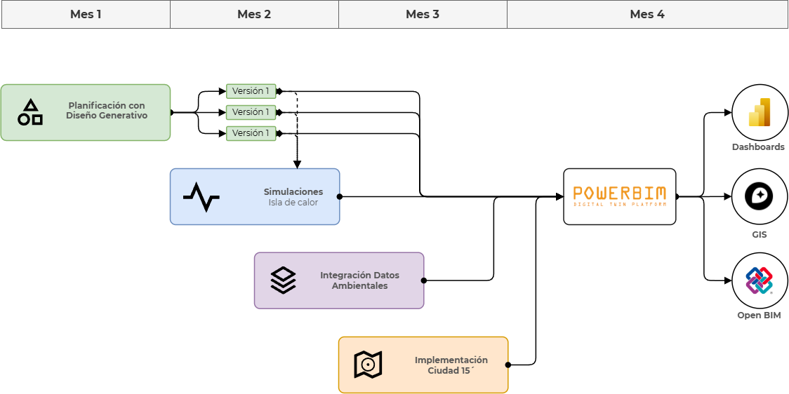
WHAT HAS BEEN DEVELOPED

FROM GENERATIVE URBAN DESIGN TO A DATA COMPARISON INTELLIGENT PLATFORM FOR A 15 MINUTES CITY

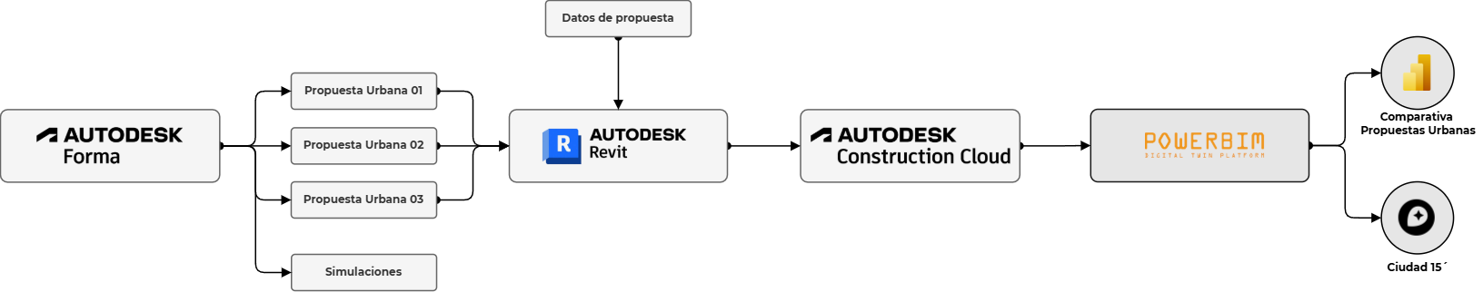
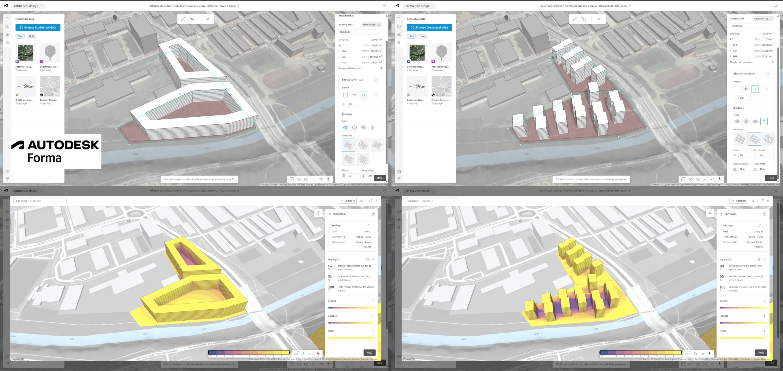
GENERATIVE URBAN DESIGN WITH AUTODESK FORMA

Generative Urban Design with Autodesk Forma enables urban planning teams to rapidly create and evaluate multiple design scenarios in just minutes, without requiring advanced technical expertise. This empowers municipal urban departments to explore different urban configurations early in the process and immediately test their performance through environmental simulations, such as urban heat island analysis, based on real local conditions. These simulations help identify optimal urban layouts that enhance shading in public spaces, improve thermal comfort, and strengthen climate resilience.

The approach focuses on generating multiple parametric and OpenBIM-based models from which key urban indicators—such as building density, number of dwellings, and land use distribution—can be extracted and validated. This allows decision-makers to assess the feasibility and quality of design options before reaching the preliminary design stage. Ultimately, this tool enables public administrations to define robust urban criteria prior to launching tenders, ensuring that architectural proposals are developed on well-informed, data-driven urban foundations.

Main Objectives:

  • Enable non-technical users to generate and compare multiple urban design scenarios rapidly
  • Integrate environmental simulations (e.g., heat island effect) from early stages
  • Optimize urban layouts to improve shading, comfort, and climate resilience
  • Generate parametric, OpenBIM-ready models for downstream use
  • Extract and validate key urban indicators (density, dwellings, land use)
  • Support early decision-making before preliminary design phases
  • Define strong urban frameworks to guide future architectural competitions

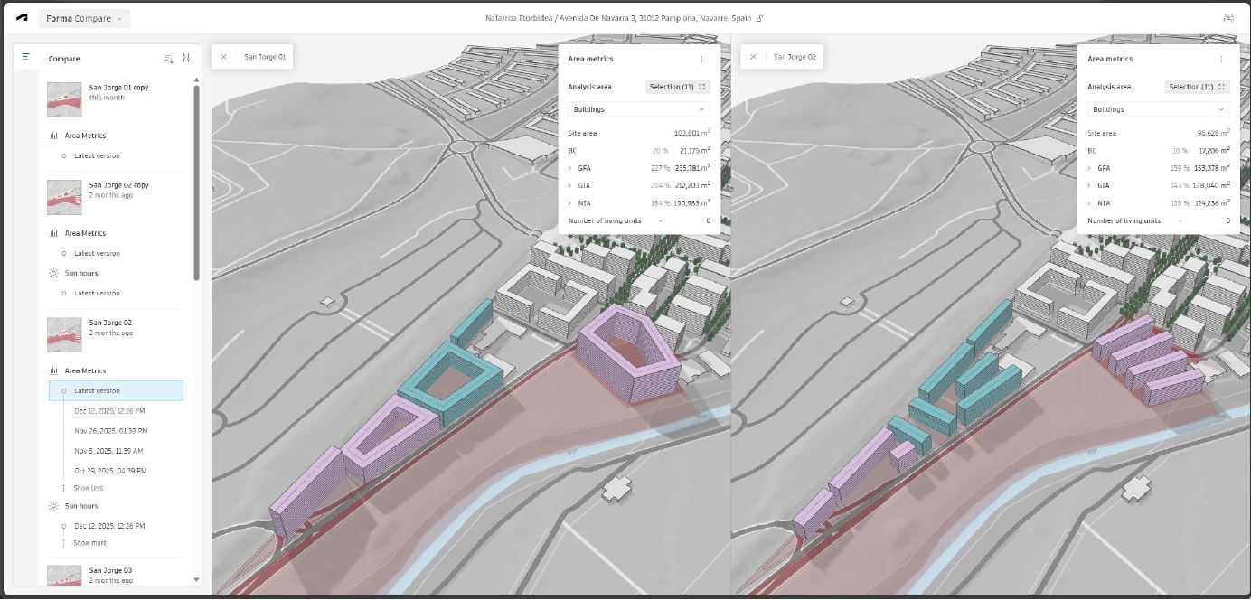
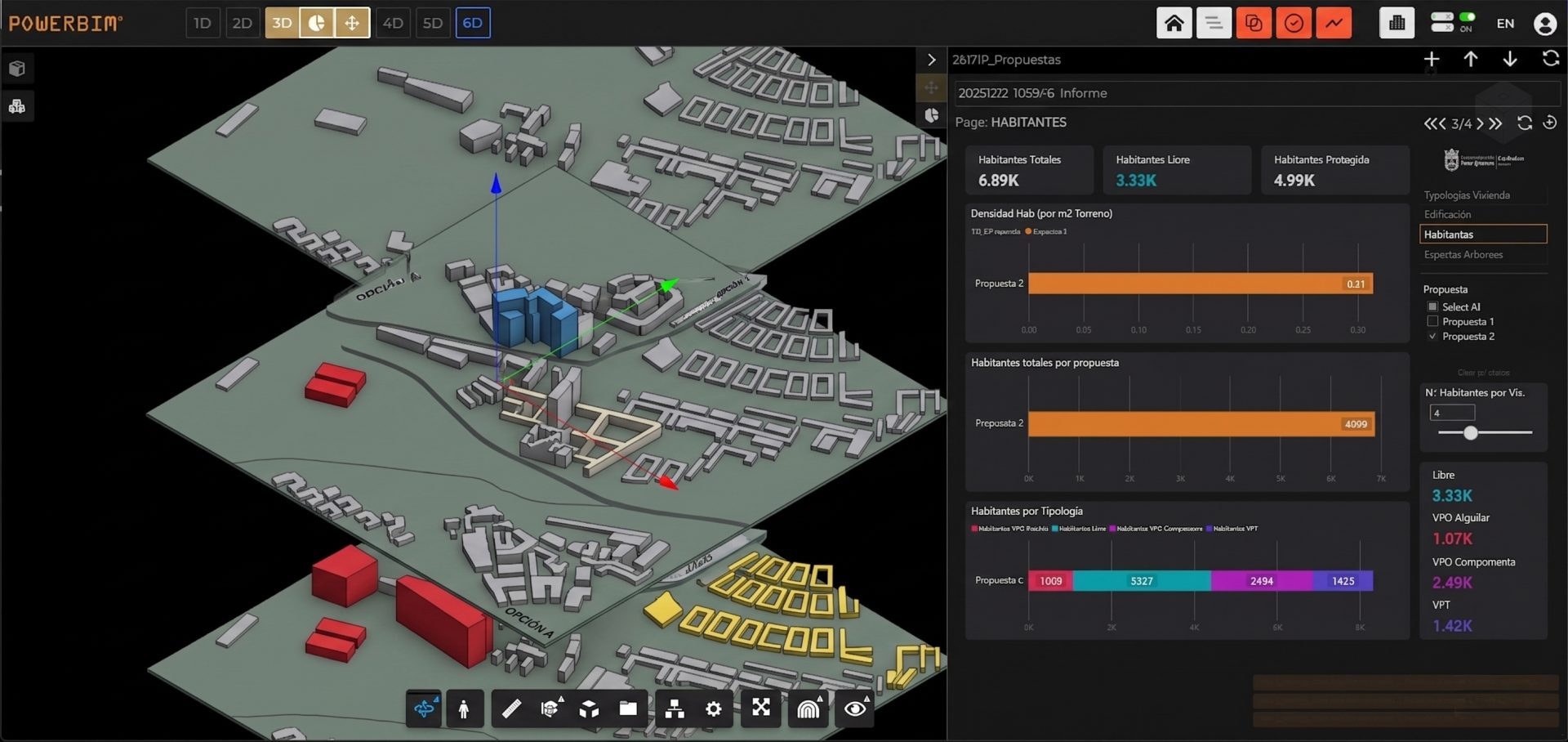
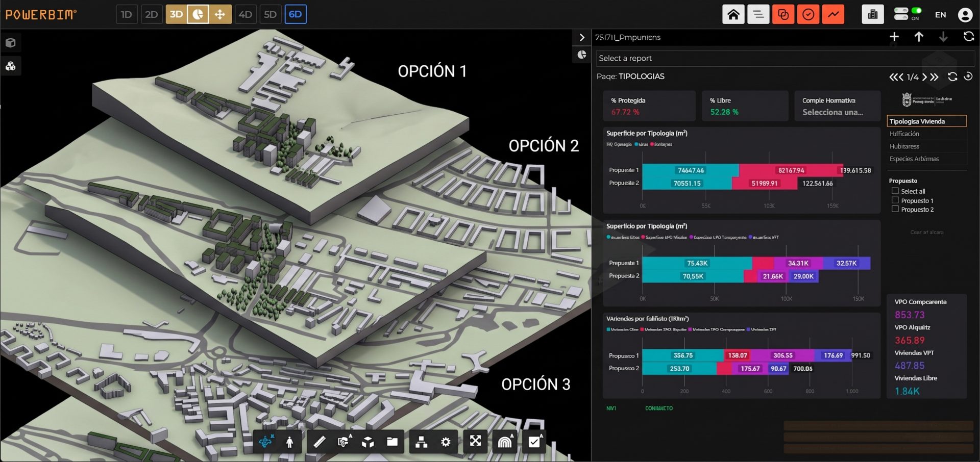
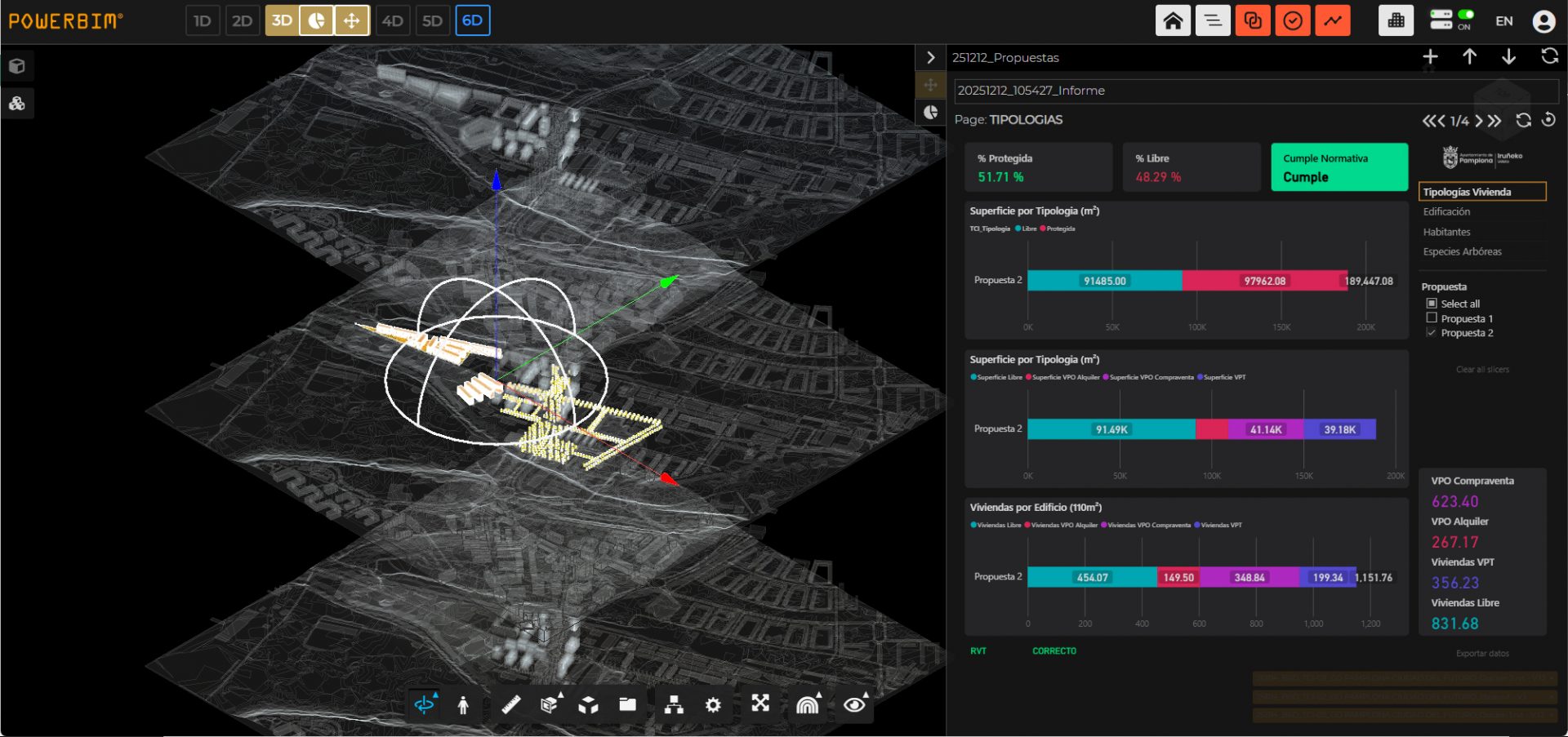
POWERBIM DIGITALTWIN FOR URBAN OPTIONS COMPARISON

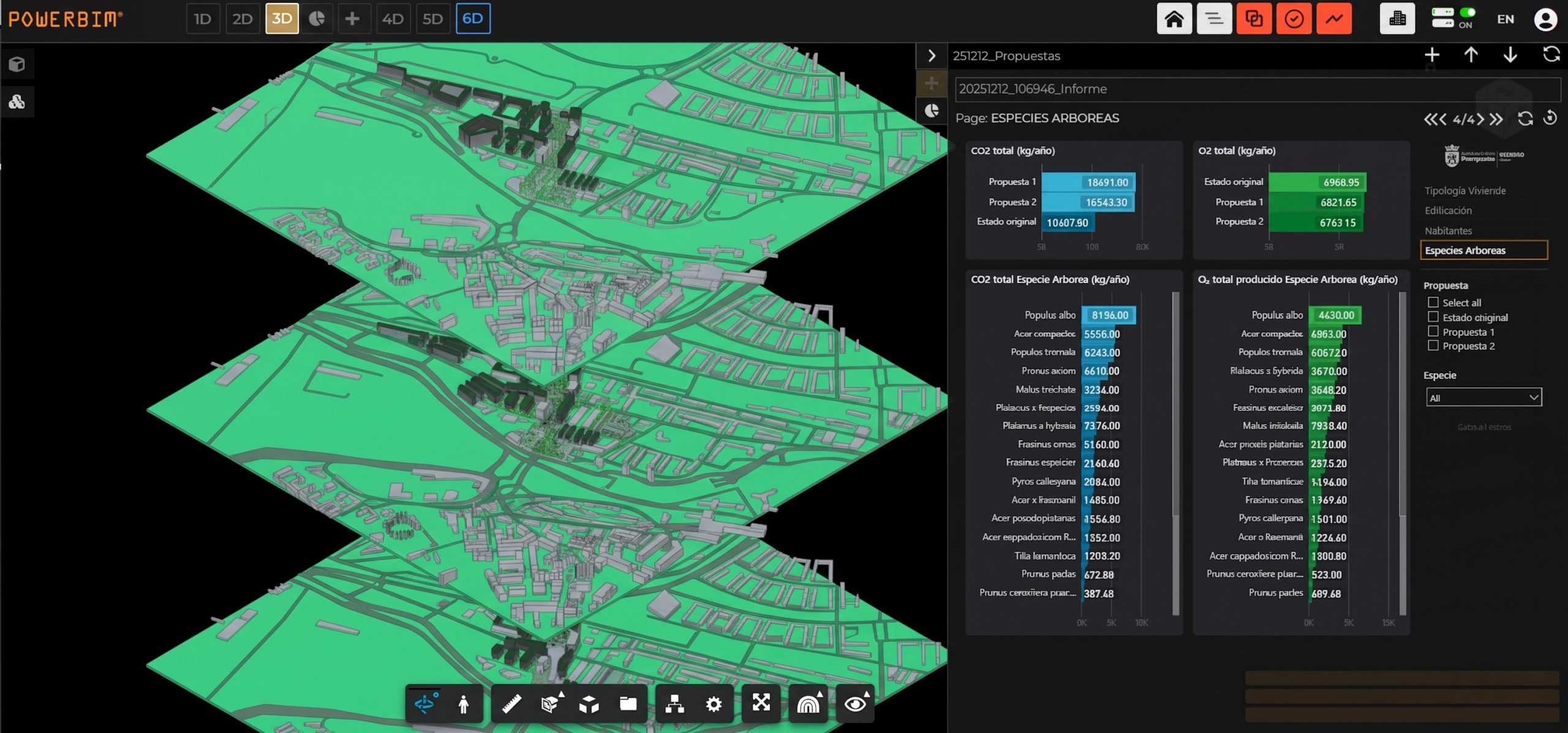
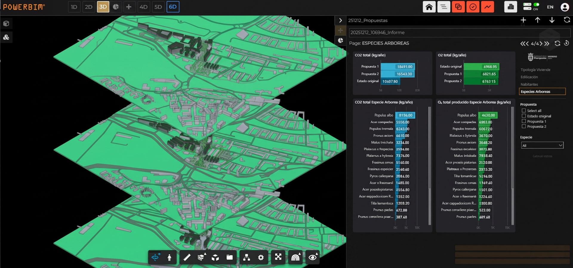
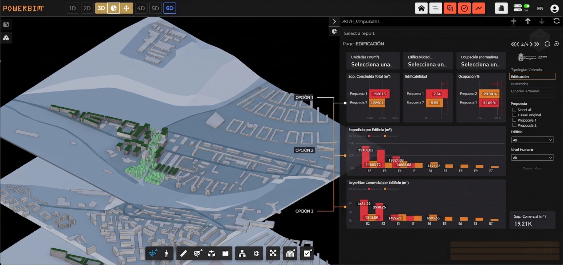
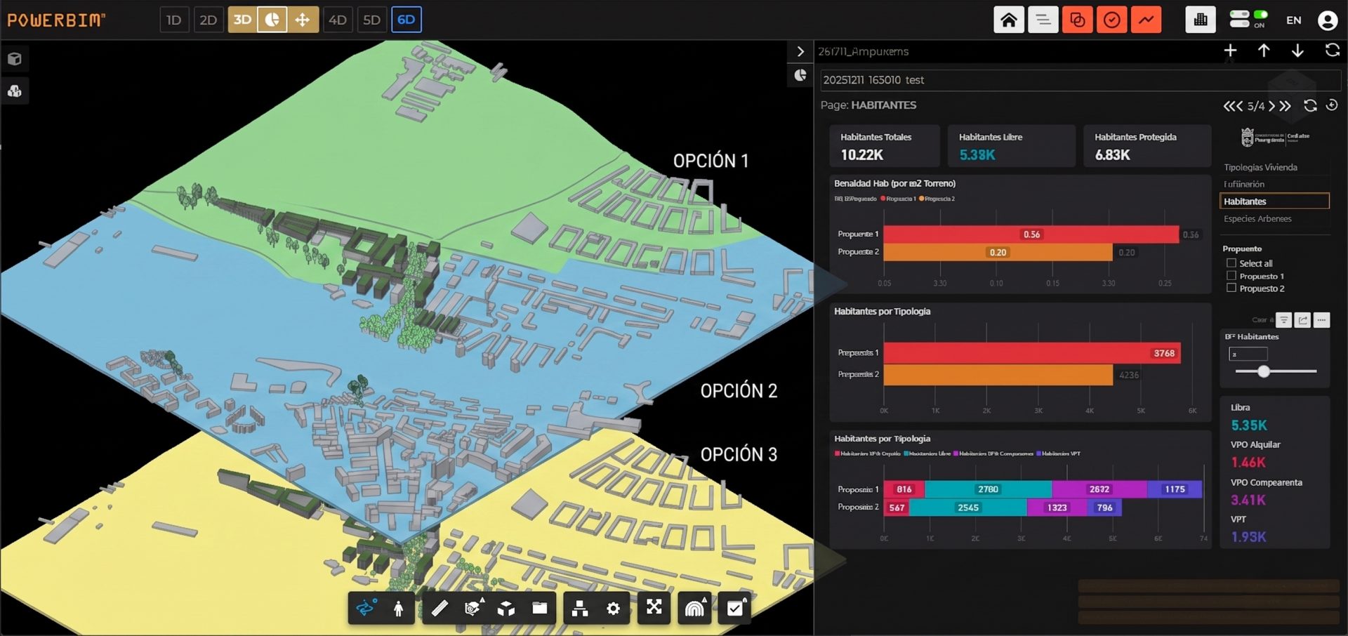
POWERBIM enables a fully operational urban digital twin environment where multiple urban design options, generated in minutes through Autodesk Forma and exported as BIM models, can be instantly compared using data-driven analytics. Once different design scenarios are loaded into the platform, a single analytical dashboard automatically extracts and processes key urban data and KPIs, previously defined in collaboration with the Pamplona City Council.

These include indicators such as number and typology of dwellings (social housing, regulated, private), estimated population based on housing characteristics, building density, façade surface, total built area, public space distribution, and even carbon footprint estimations linked to green infrastructure strategies (e.g., tree species in public spaces).

By connecting BIM models with advanced analytics, POWERBIM transforms urban design alternatives into measurable, comparable scenarios, enabling objective and transparent decision-making. This approach significantly accelerates processes that have traditionally been slow, manual, and costly, allowing public administrations to evaluate multiple options in a short time and select the most balanced solution in terms of social, environmental, and urban performance.

Main Objectives:

  • Compare multiple urban design scenarios through a unified digital twin environment
  • Automatically extract and analyze key urban KPIs from BIM models
  • Support evidence-based decision-making with real-time dashboards
  • Evaluate housing distribution, density, and population impact
  • Integrate sustainability metrics, including carbon footprint and green infrastructure
  • Reduce time and costs in urban planning and evaluation processes
  • Enable faster, more informed selection of optimal urban development strategies

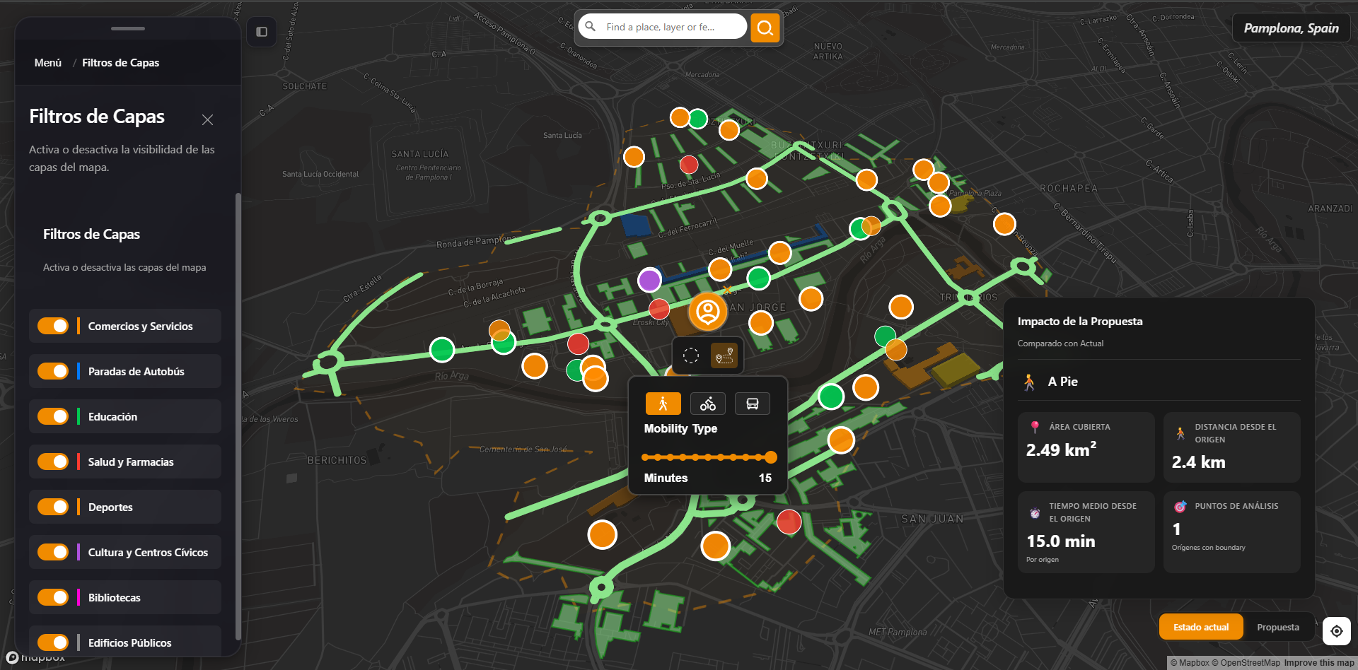
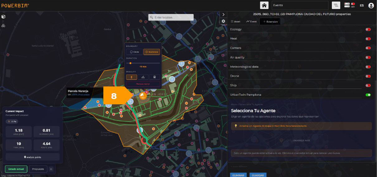
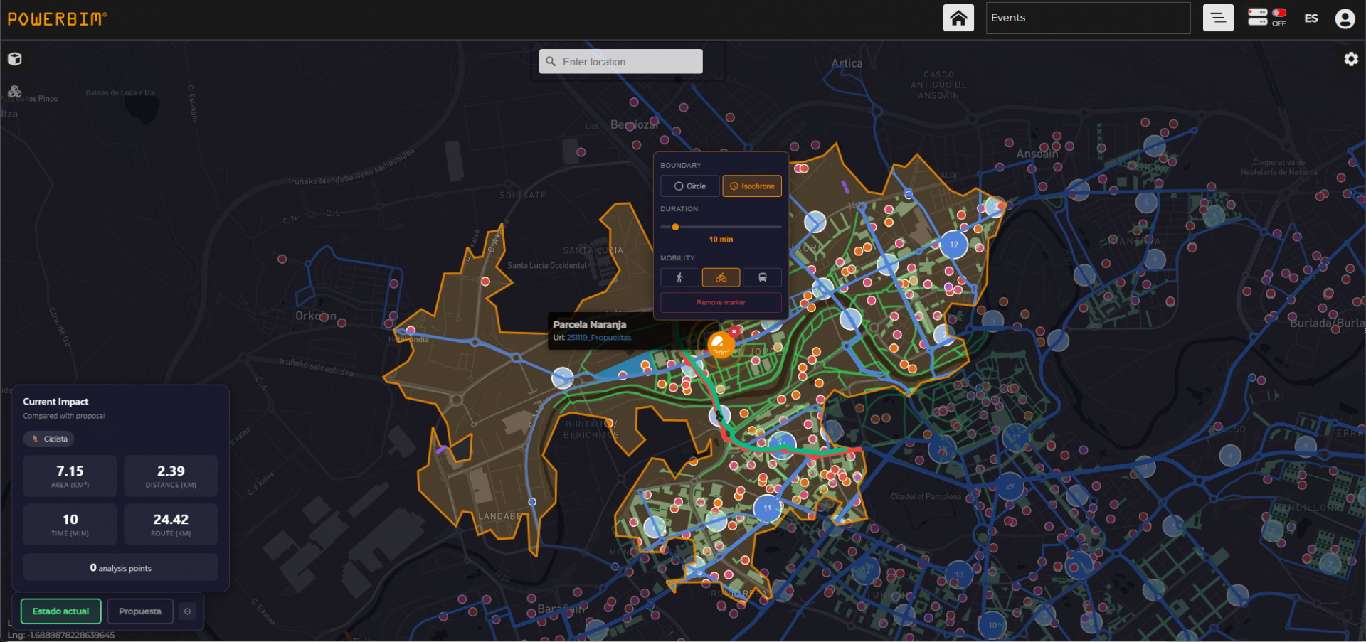
15 MINUTES CITY SIMULATION

The 15-Minute City Simulation developed within POWERBIM integrates an advanced GIS open-source module enhanced with an AI-driven agent, enabling intuitive and dynamic accessibility analysis across the city of Pamplona. By simply selecting any point on the map and choosing a mode of transport—walking, cycling, or public transport—the system automatically loads real transport network data from Pamplona’s GIS platform and generates a reachable area within a defined time interval (default 15 minutes, adjustable by the user).

This interactive functionality visualizes the actual catchment area, overlaying key urban layers such as public facilities, transport stations, and other relevant services. It allows planners and decision-makers to instantly assess whether both existing urban areas and proposed developments meet accessibility standards to essential services within a reasonable timeframe.

By combining real mobility data with spatial analysis, this tool becomes essential for validating urban proximity strategies, promoting sustainable mobility, and ensuring equitable access to high-quality public services. It supports the transition towards a more inclusive, efficient, and citizen-centered urban model aligned with the principles of the 15-minute city.

Main Objectives:

  • Analyze real accessibility to services based on different transport modes
  • Visualize 15-minute catchment areas dynamically and interactively
  • Integrate real GIS transport data from Pamplona
  • Evaluate proximity to public facilities and key urban services
  • Validate urban design proposals against accessibility criteria
  • Promote sustainable mobility (walking, cycling, public transport)
  • Support equitable and efficient urban planning decisions

Collaborative Innovation with Public Administration and Twin Navarra

Throughout the development of this project, we have had the privilege of working closely with the public administration, particularly the Pamplona City Council and the Twin Navarra team. This collaboration has been highly enriching, allowing us to share knowledge, align objectives, and create synergies not only with the administration but also with other companies involved in parallel challenges within the program.

We are especially grateful for the continuous support and for the opportunities to present our work in events where the value of our solution—and the broader potential of digital twin technology for public administration—has been recognized. These spaces have reinforced the importance of innovation as a key enabler for better urban governance.

Public administrations play a critical role in ensuring that cities effectively respond to today’s challenges. Among these, improving accessibility, enhancing the design of the urban environments where we live, strengthening our relationship with the natural environment, and addressing increasingly important social dynamics are essential priorities. We firmly believe that digital twin technology can become a fundamental tool to support these objectives, enabling more informed, inclusive, and sustainable decision-making.

    Join our Newsletter

    We'll send you newsletters with news, tips & tricks. No spams here.

      Contact Us

      contact us for anything you think we can help you with, we will be happy to give you an effective answer